Marker at LaGrange Church LaGrange Church Hernandez Trail Marker
HISTORICAL MARKERS PLACED BY PHILIP PERRY CHAPTER
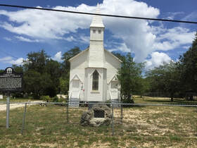
LA GRANGE CHURCH "SITE OF THE FIRST CHURCH ERECTED BETWEEN NEW SMYRNA AND KEY WEST. A COMMUNITY CHURCH BUILT 1869." MARKED BY PHILIP PERRY CHAPTER of the Daughters of the American Revolution - 1941 On March 6, 1942, a historic marker was placed in front of the oldest church between New Smyrna and Key West in Florida. La Grange Church and Cemetery, built in 1869 and located on Old Dixie Highway just north of Titusville, was the social center for the early settlers. The LaGrange church is also the oldest Protestant church between St. Augustine and Key West. Non-denominational religious services and all-day meetings with dinner served on the grounds were typical in the early days of the church. The usual fare served was wild hog, venison, turkey, and mullet served with cabbage palm, mangoes, and sweet potato pie. La Grange Church is on the National Register for Historic Places. The DAR Marker was placed when Philip Perry Chapter was chartered in Titusville, before the chapter's move to the city of Cocoa.
Located on North Dixie Avenue just north of Dairy Road Latitude: 28.639612, Longitude: -80.837151.
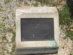
HERNANDEZ TRAIL "HERNANDEZ TRAIL -- 1837 - 1928" MARKED BY PHILIP PERRY CHAPTER of the Daughters of the American Revolution - 1928 On June 28, 1928, the original marker, encased in a large boulder of native coquina rock (mixture of shell fragments and quartz grains bound together by calcium carbonate), was placed to mark this trail used by area pioneers during the Seminole Indian Wars from 1817 to 1858. Some portions of the trail are still visible on aerial photos throughout Brevard and Indian River counties. In 1992, the marker was replaced with a smaller marker at the intersection of Airport Road, at Old Dixie Highway in Titusville, with the cooperation of Florida Board of Parks and Historic Markers.
Located in the island at the intersection of North Dixie Avenue and (Dunn) Airport Road Latitude: 28.621022, Longitude: -80.829683.